

Wellington City Council can now provide, at a glance, data on buildings in six pre-1930s character areas. It’s all thanks to a GIS initiative.
Character assessments and similar stock-taking reports have typically been time-intensive and expensive undertakings for local councils. It was challenging to quickly and comprehensively analyse the report findings and present those conclusions effectively in a public forum.
A Wellington City Council character area survey that used an innovative geospatial approach to data collection and reporting has effectively addressed those challenges. The New Zealand Planning Institute recognised its success with the Best Practice – Strategic Planning and Guidance Award at its recent annual conference in Napier.
Last year, Wellington City Council (WCC) undertook a stocktake of the six pre-1930 character areas contained in the residential chapter of the Wellington City District Plan. The study included a review of the ‘on the ground’ character of these areas that primarily focused on the level of concentration of pre-1930 buildings, and the extent to which those buildings contribute to ‘townscape’ and/or ‘streetscape’ character.
WCC contracted planning consultancy Boffa Miskell to perform the stocktake. In addition to a comprehensive data set on the 5500 properties within the pre-1930 character areas, WCC wanted a flexible tool that would enable it to easily and effectively engage with a diverse range of audiences in real-time.
It was also important that residents were able to access the information independently, rather than having to go to the council office, or being required to attend a scheduled engagement session.
“We commissioned the work because we needed a complete set of information about these character areas and an effective way to convey that information to the public as part of our Planning for Growth work,” says Kate Pascall, WCC’s principal advisor for planning.
The wider Planning for Growth project has five goals: Compact; resilient; greener; vibrant and prosperous; and inclusive and connected. These goals are derived from previous community engagement. A big part of this is sense of place and identity.
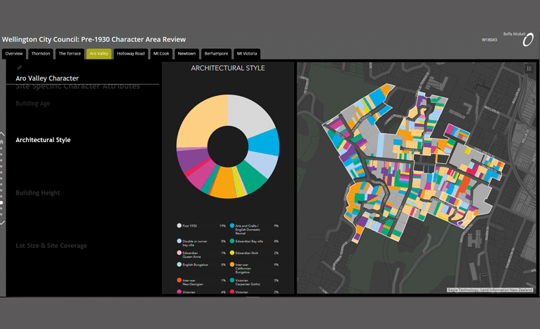
The review needed to display significant amounts of data in a way that would be meaningful at a range of scales – from individual properties, to streets, to the entire area. Taking a geospatial approach to data collection, analysis, field verification and reporting enabled the project team to deliver on all fronts.
A review of relevant background documentation, including urban design guidelines, character assessments and heritage studies previously commissioned by WCC led to the preparation of an overview of the styles of domestic architecture in each character area covering the period pre-1880 to 1930. Sixteen representative architectural styles spanning these decades were identified.
Architect and conservator Ian Bowman advised on the architectural styles and period styles.
“The styles are an indication of the ages of the buildings in the areas. Take, for example, Thorndon and Te Aro – they were the first settled in Wellington, so they have the oldest buildings. On streets in those neighbourhoods, you’d expect to see small cottages from the 1850s and ’60s, but there are also fairly large houses that were Italianate in style.”
Attributes for the data collection fell under three categories: streetscape character, property-specific character and the extent of character contribution.
Using a desktop application for initial data capture on each property was an efficient way to populate as many data fields as possible using existing information provided by WCC and augmented with information gleaned from Google Maps and Google Street View.
The project team configured proprietary software to create a cost-effective method of data collection, which then freed time and budget for a comprehensive field verification of property data.
Field verification of the property data compiled during the desktop analysis was undertaken by two- to three-person field teams using an iPad app. This also included an assessment of the contribution that each property makes to the overall character of the street and wider environment, and capture of geo-referenced photography.
“Field assessment became a step of verification and correction, rather than data collection,” says project lead Greg Vossler, senior planner at Boffa Miskell. “We were able to move through the character areas quickly and efficiently by leveraging the technology to perform a very thorough assessment.”
Ian Bowman agrees. “The traditional way of these surveys was to just start with site visits. You’d go out with pad and paper and camera to have a look; take notes on paper, make a list of what addresses you’d photographed; then go back to the office, download the photos, write the notes up… it was a time-intensive process.”
“Using the app meant that the data was updated in real time,” says Greg. “The data is all geo-referenced, so you know exactly what photo and what information goes with what address. Additionally, because the field teams were all working in real-time, we could see what streets and properties had already been surveyed.”
Leveraging off the data collected, the ArcGIS platform enabled development of a series of area-specific dashboards with interactive charts and statistics. Filters can easily and intuitively be applied, allowing the user to refine the data in real-time.
“These StoryMap dashboards are interactive, so residents can apply filters and work through the information in their own time and at their own pace,” says GIS specialist Hayley Hume-Merry.
“A massive amount of information and data trends are analysed and presented in a highly graphic manner that is easily understood by the lay person.”
The project team’s use of off-the-shelf software facilitated creation of a data package and online application to be handed over to WCC enabling future development. It also provides a useful data baseline to be used for future reference and as the basis for any subsequent reports.
Without any further work, the findings of this review can be exposed to the public and used by WCC as a live interactive engagement tool, in aid to, or in replacement of, face-to-face community meetings with the potential to reach a wider audience.
“It was important that the public were able to access this information independently, rather than having to go into the council offices, or even going to an engagement meeting,” Kate Pascall says.
“Wellington City Council now has a comprehensive data set on those properties and areas, and a very engaging way to present that information.”
This article was first published in the May 2019 issue of NZ Local Government Magazine.