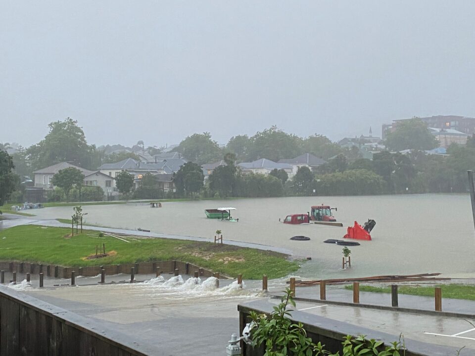


Caption: Balmoral School playing field turned into a huge lake that spilled into the local suburb flooding housing during the storm over Auckland, January 27, 2023.
A prime example of an area in Auckland still suffering from a lack of drainage investment as it infills with new dwellings is the Gribblehirst Park/Eden Park catchment. By Alan Titchall.
Since this article was published in the November issue of Local Government magazine, Auckland suffered a major flooding disaster over the city’s anniversary weekend, January 2023 that was on an unprecedented scale.
An area in the north-west corner boundary of Mt Eden and Sandringham (near Eden Park) in Auckland is a natural depression, once known before being drained and filled 100 years ago, as ‘Cabbage Tree Swamp’.
It was developed as a housing estate in the first half of the last century with a combined stormwater and wastewater drainage system. Sitting about 50 metres above sea-level in the Auckland inner city, stormwater is pumped from this area into the neighbouring Meola Integrated Catchment Area, which is the largest aquifer in the Auckland region and a major part of Auckland’s drainage network. A major concern for the city’s water engineers, this catchment has always been under pressure with a history of intense flooding.
When the Meola Catchment is at capacity during a severe weather event, so typical in Auckland, the combined wastewater- stormwater system in the North-West Mt Eden-Sandringham depression cannot cope for a few hours, with consequent flooding that has occurred since the area was developed into a residential area in the early 1930s.
Over the past three decades there have been two Auckland Council engineering studies aimed at this problem. The first was in the early 1990s and called the Meola Stormwater Plan, which was released around September 1994. Interestingly, it pointed to the redevelopment of the Balmoral School 1982/83 in this area having had “generated additional runoff”. That school has since doubled in size, and had just completed a major rebuild prior to intensive flooding in March this year (see photos).
In the original Meola Stormwater Plan, council engineers came up with ‘three solutions’ for this area. The first was upgrading the existing stormwater system from the main watercourse to Cricket Ave near Eden Park with a new stormwater tunnel at Taylors Road to Cambourne/Parrish Road area (cost $21 million). The second option was intensive subsoil soakage by drilling soak holes that was estimated to cost $15 million. The third option was buying or raising affected houses at a cost of $60 million to create a new, wetland park.
In 2012 the Auckland Council (through its Healthy Waters division) carried out the Central Auckland Stormwater Initiative (CASI); a project looking at stormwater infrastructure upgrades with co-ordinated planning with the Central Interceptor (CI) project currently being carried out by Watercare Services. This study was also on top of numerous environmental studies conducted in the Meola Catchment, such as the Meola Watercourse Management Plan.
The CASI conclusions in 2012 are very similar, if not identical in parts, to the 1994 report that, basically, natural soakage won’t cut it anymore.
In the 2012 study the $21 million estimated in 1994 for a new stormwater tunnel between Taylors Road and the Cambourne/Parrish Road area was now estimated as costing $200 million for the basic large pipe network; $50 million for stream capacity upgrades to Meola Creek; and up to $200 million for small stormwater network to connect up and separate some key areas. The council estimates that in 10-years’ time, given the current price rises in the construction industry, it could probably double these 2012 estimates.
Meaning – that the cost of a new drainage solution for the number of dwellings in the area is prohibitive and the CASI report even proposes buying properties affected by the flooding and turning the area into parklands, or raising properties above flood levels.
We have been told by council engineers that the Central Interceptor project will not make much difference to these catchment areas.
Meanwhile the infill and infrastructure pressure continues
These catchments have traditionally been one of single, one-storey homes and restricted development in acknowledgment that it is a natural flood zone with an aging and combined stormwater-wastewater system that also relies heavily on natural soakage.
With changes to the Auckland Council’s own Unitary Plan going back to 2014, this area has already been re-zoned ‘mixed housing’, which is a reasonably high-intensity zone allowing for development up to three storeys (11 metres) in a variety of sizes and forms including terrace homes, low-rise apartments and detached dwellings. However, no upgrades have been done to the wastewater-stormwater drainage system.
Now, the Government’s amendments to the NPS-UD policy in December last year through the Resource Management (Enabling Housing Supply and Other Matters) Amendment Act, requires the Auckland Council, and every other tier one council, to increase urban intensity in its Unitary Plan, but has left it to the council to work out which urban centres are suitable and what building heights and density to enable.
Ironically, the Albert-Eden council board before the 2022 local elections was in favour of greater intensification, while the council works through its qualifying matter exemptions, that do include infrastructure.
John Duguid, the manager of Plans and Places at Auckland Council tells us: “The Auckland Unitary Plan already includes rules that prevent development in specified flood plains unless a resource consent is obtained. Those rules take increase in storm events into account and the council intends to keep them in place. In some parts of the city the Auckland Unitary Plan also requires onsite detention/retention of stormwater to minimise the downstream effects of stormwater. Again, those rules will continue to remain in place.
“We are also looking into stormwater infrastructure limitations as a potential qualifying matter, particularly where there are no practical solutions to resolve these constraints. We are still in the process of working out whether and how this qualifying matter could apply, and the extent to which further intensification might be limited.
“The fundamental premise we are operating under is to not increase flooding risk as a result of intensification. The key considerations relate to additional development within areas subject to flooding, and the increase in impervious surface areas, as this may increase risk to people and property.
“Impervious surface areas are things like roofs, concrete pavements and driveways, where stormwater won’t be able to infiltrate into the ground. The creation of more impervious surface areas which can happen through development will result in the generation of additional runoff downstream.
“The National Policy Statement on Urban Development and the government’s recent changes to the Resource Management Act do not require the council to relax the current rules in the Auckland Unitary Plan that control the amount of impervious surface area that can be created on a residential-zoned property.”
Comforting words, but is it working in practice as catchment areas such as Meola Integrated Catchment Area and Gribblehirst Park/Eden Park catchment gradually fill with new residential developments while the Central Auckland Stormwater Initiative report and its warnings turns into another council historical document?