
Auckland Council’s Planning, Environment and Parks Committee says it has a new strategy for developing its city over the next three decades as it is expected to grow by half a million more residents by 2053.
Mayor Wayne Brown describes the Future Development Strategy as; “Making the most of our existing infrastructure and limit the loss of agricultural land to housing, especially where it is expensive to provide services. “It is sensible to plan for housing and business needs in good locations. This also means avoiding development in high-risk locations, where flooding and natural hazards are a risk to people and property.
“Further, existing ratepayers don’t want to subsidise new greenfield developments. We’re showing our commitment and showing the signals for a more balanced urban plan; this is appropriate for New Zealand’s fastest-growing region.”
Chair of the Planning, Environment and Parks Committee, Councillor Richard Hills adds that it is also “an honest assessment of the infrastructure Aucklanders are able to afford when many communities feel there hasn’t been enough investment in current urban areas already.”Jacques Victor, General Manager of Auckland Plan, Strategy and Research says the way the Council has managed growth by focussing growth in existing urban areas and some in greenfield areas – remains largely the same for the future.
The two significant changes are a stronger focus on responding to flooding hazards and protecting people and property, and “a greater recognition of the council’s financial challenges and when we can invest in essential infrastructure and services, especially in areas on the city’s edges.
“Growth in greenfield areas remains an important part of the council’s overall strategy for Auckland’s growth and for making sure people have housing choices.
“However, we want to avoid building homes in places without the necessary infrastructure and services. That’s not good for communities, our environment or people’s well-being.”
Key points are a small reduction in greenfield land previously indicated for future urban development, around 800 hectares in Hatfields Beach and parts of Kumeu-Huapai and Riverhead, Takaanini and Drury, which are exposed to significant flooding risks.
Focus on significant infrastructure investment in priority areas over the next 10 years include Westgate, Tamaki, Mount Roskill, Mangere, Drury, and Auckland’s City Centre.
While Auckland has already planned for a huge amount of capacity for residential and business growth over the next 30 years, not all of this will likely be developed. Direction is given for more housing capacity to be created over time in locations of high demand, with good accessibility and with low hazard risk, mainly around town centres and public transport routes.
The new plan recognises the need for business land, especially large format business, and therefore brings around 250 hectares of business land in Whenuapai forward to 2025, as well as business land in Silverdale and Puhinui over the medium term.
Commenting on whether the new Government should have a say in the council’s plans, Mayor Wayne Brown, a critic of the last government’s’ meddling in local council business, says the city needed to make its own decisions. “Auckland has to determine what Auckland is going to be like.
“We would have a better city already if the last government hadn’t meddled, or the one before that either, that was the whole point of having local government. The word local is a clue.”
Brown says the population of Auckland is growing at a rate that the city’s infrastructure can’t keep up with. At least with in-fill, you are using infrastructure which is here, he says.
“The trouble with greenfields is that, whilst the developers put the infrastructure in within the actual subdivision itself, that subdivision demands more – stuff that we have to pay for.”
Which doesn’t account for the fact a lot of the city’s infrastructure can’t cope with the infill of the past two decades. Under more pressure from extra bathrooms and kitchens – can only result in more central Auckland flooding in the future. LG asked Jacques Victor, Auckland Council GM for Plan Strategy and Research this question.
“Where the FDS supports creating more housing capacity over time, it clearly states this will occur in locations that are not subject to hazards like flooding. This doesn’t mean accommodating growth everywhere across urban areas and in hazard-prone areas. The FDS also prioritises investment in improving and maintaining infrastructure in existing urban areas to support future growth.
“Development is to be avoided in areas exposed to hazard risks where further development is inappropriate.
“It’s important to mention that the FDS doesn’t rezone or upzone existing urban areas. Decisions about where intensification is appropriate in specific locations are made through the Auckland Unitary Plan, which considers various factors, including stormwater management and flooding risks.”
Victor adds that work to strengthen the Auckland Unitary Plan (AUP) in response to natural hazards, including flooding, is already underway, with community engagement on a Natural Hazards Plan Change to begin in 2024, with notification in 2025.
“This work will also now need to consider central government’s proposed National Policy Statement on Natural Hazards Decision Making, which is expected to be gazetted in early 2024.”
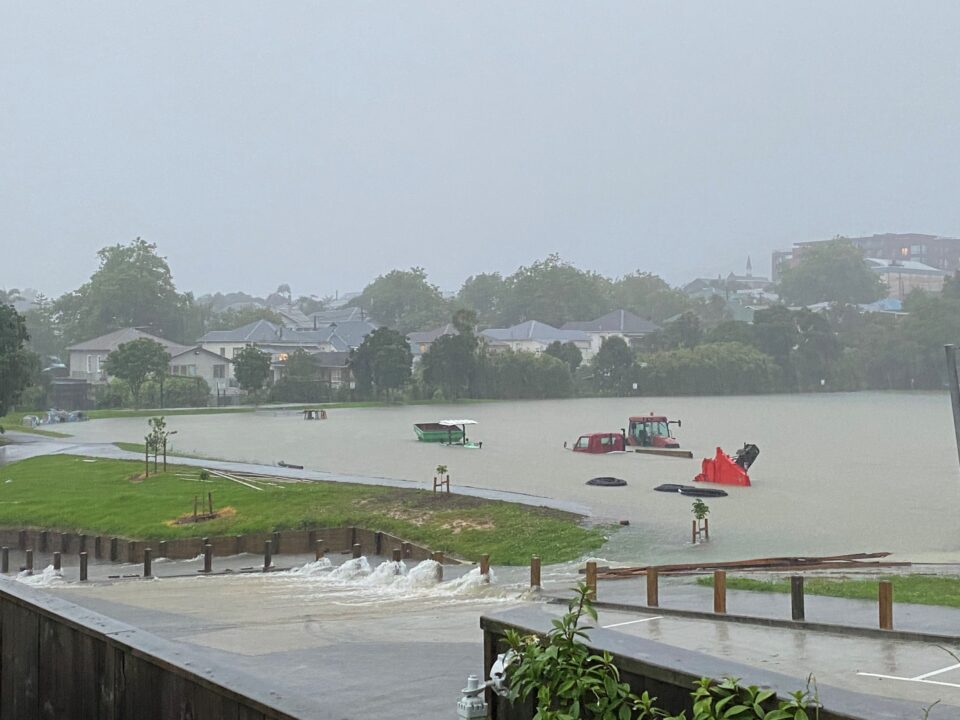
Caption:
The redeveloped Balmoral School playground in Auckland turned into a deep lake during heavy rains on January 27, 2023. Stormwater spilt out down the school driveway to flood the neighbouring community.